CALIPSO flight template
This flight will be dedicated to the validation of CALIPSO cloud products with observations of upper clouds structure and microphysics (incl. size and shape of ice crystals).
CALIPSO is part of the A-train and follows a sun-synchronous orbit, the ascending node crossing the equator at 13:43 local time. There is a 16-day repetition cycle.
Figure 13 shows CALIPSO ground-tracks in Ouagadougou area in August 2006. The day is color-coded from August 1 st (which is day 1). The circle centred on Ouagadougou has a radius of about 800 km. Daytime over-passes are for ascending orbits from South-East to North-West. As an example, CALIPSO ground-track is very close to Ouagadougou daytime on 6 August (black solid line)
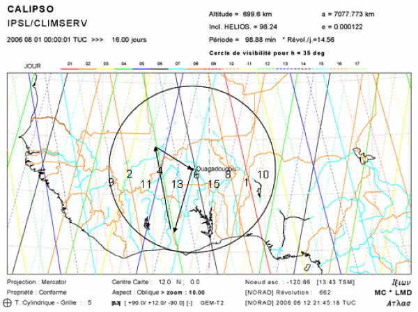
Assuming that the M55 can reach the footprints included in the black circle, we give below possible days between August 2 nd and August 15 th and time (UTC) for a daytime CALIPSO sub-orbital flight as well as the corresponding shortest distances (in km) and location (longitude and latitude) from Ouagadougou.
| Day | Time (UTC) | Distance (km) | Long, Lat |
|---|---|---|---|
| 02/08/2006 |
14:05:28
|
626.1
|
-7,19° ; 11.32 °
|
| 04/08/2006 |
13:53:15
|
296.8
|
-4.19° ; 11.76°
|
| 06/08/2006 |
13:41:06
|
31.7
|
-1.26° ; 12.47°
|
| 08/08/2006 |
13:28:57
|
359.1
|
1.69° ; 13.12°
|
| 09/08/2006 |
14:11:39
|
790.5
|
-8.67° ; 11,04°
|
| 10/08/2006 |
13:16:47
|
685.8
|
4.64° ; 13.75°
|
| 11/08/2006 |
13:59:27
|
461.1
|
-5.69° ; 11.57°
|
| 13/08/2006 |
13:47:16
|
132.3
|
-2.72° ; 12.10°
|
| 15/08/2006 |
13:35:07
|
195.9
|
0.22° ; 12.82°
|
As A-train maneuvers are scheduled from August 15th , which may impact CALIPSO payload operations, we keep from this table following days: August 6, 13, 4, 8, 11, 2, 10, 9 August 15 is also a day of interest if nominal operation of CALIPSO is confirmed.This information will be updated in July/August before M55 deployments but only slight changes of time and distance from Ouagadougou are expected. Choice on the preferred day will be done on the basis of cirrus forecast, i.e. high altitude semi-tranparent clouds.
The M55 will fly along the CALIPSO footprint, about 30 minutes before and after CALIPSO overpass (about 1 hour in total) at time T0, with altitude excursion.
Good CALIPSO validation could be achieved by vertically sampling thin (overall optical thickness below 3) cirrus clouds. A case of interest could be if those clouds are layered at different altitudes.
The M55 will head toward a region where cirrus clouds are likely to be encountered (see Figure 13 for illustration of the flight path, assuming to fly on day August 4 th ). Once there, it will cross the tropopause, and perform vertical excursions downwards and upwards across the high altitude clouds of interest in order to get vertical profiles of backscatter coefficient, microphysics and water vapour. A vertical resolution of 60 m would be optimum to match CALIPSO vertical resolution. Assuming about 4 m/s ascent/descent speed, the desired vertical resolution can be achieved for the instruments having a response time of 15 seconds or less. Assuming an horizontal speed of 220 m/s, it would correspond to 3.3 km horizontal resolution which matches the 5-km horizontal resolution of CALIPSO cloud profiles.
For cloud with optical thickness thinner of thicker, the vertical speed of the ascent/descent might be adjusted to balance instrument sensitivity with good horizontal resolution. In fact the ascent/descent speed of 4-6 m/s could be slower if the underpass is close to Niamey or could be a series of discrete steps with faster vertical changes. This has to be discussed with the pilot, in order to get as close as possible to our aims. Figure 14 shows a time-height template for the CALIPSO flight. Time T0 is 2 hours for this plot. Assuming a 6 km vertical excursion from 19 to 13 km downwards and upwards with a vertical speed of 4 m/s, both vertical excursions would take about 1 hour.
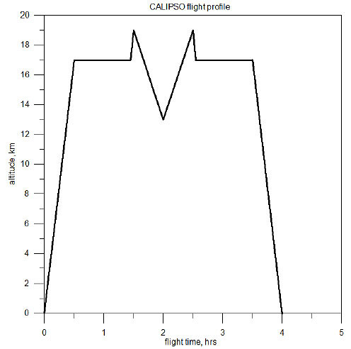
Time-height flight profile for the CALIPSO validation flight. The central part of the flight should cross a cirrus cloud, with a vertical speed of 4 m/s.
The ferry flights, and the time of flight out of the CALIPSO validation time, will be eventually devoted to cirrus sampling in that region.
 top
top- M55-AMMA-SCOUT-O3 Campaign Team 2006 contact: Sylwester Arabas <slayoo@igf.fuw.edu.pl>, Martin Streibel <Martin.Streibel@ozone-sec.ch.cam.ac.uk>