MCS Flight Template
Falcon
Falcon Flight Profile B1
Falcon Flight Profile B2
Geophysica
Template MCS (two flights)
(item I2 of the AMMA-TT8 document)
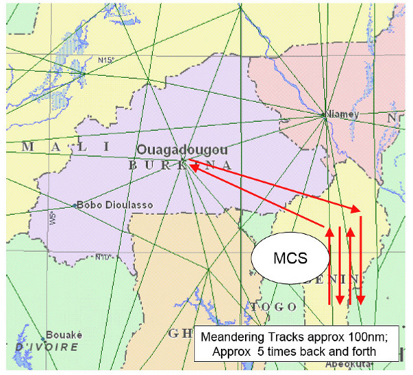
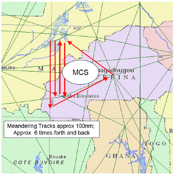
Two on-site flight will be dedicated to sampling the air above and around large Mesoscale Convective Systems (MCS). The best scenario is to sample two different systems, one closer to Niamey, the other closer to Djougou, to take advantage of the LINET devices based there; both flights will be performed in coordination with the german Falcon D-F20 based in Ouagadougou, and with the French falcon F-F20 based in Niamey. Ideal would be to have the F-F20 sampling upwind the mid-high troposphere ca. 3 hours prior the passing of the MCS in that region, while the M55 and D-F20 will fly simultaneously, the M55 above the system, the D-F20 around and downwind, the D-F20 will measure in the MCS outflow by flying through anvil and downwind of anvil while the Geophysica will fly above MCS in TTL and LS.
ATR42 and Bae146 will fly before and after MCS passage to sample the boundary layer and low-mid-troposphere .
If possible these flights will also be coordinated with balloon launching from Niamey
The M55 will fly above the MCS.
 |
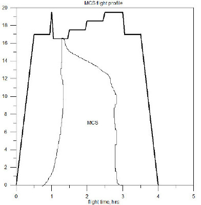 |
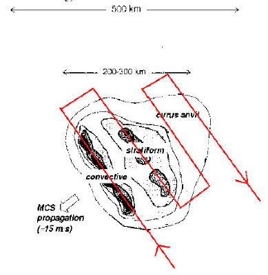
| M55 flight path above an MCS. With respect to the system's propagation, the M55 will probe the convective parts first, then the rear part of the system. | Time-height template for the MCS flight profile |
In order to perform the observation above the MCS as in figure 5, for a 1000 km overall length of the flight portion above the system, the ferry flight to and from the system should not exceed 500-700 km, given the flight range of the M55 for a safe 4 hrs flight.
At the end of the ferry flight toward the system, by approaching the advancing part of the MCS normal to its direction of propagation, the M55 will ascent from the ferry altitude of approximately 17 km to the aircraft ceiling altitude in the stratosphere, to measure the state of the LS still unperturbed by the approaching system. Then the first leg above the MCS will be flown at the level of the highest turrets of the convective clouds, namely 15.5-16.5 km; the second, third and forth legs will be flown at constant levels of increasing altitudes. This in order to probe portions of the atmosphere that should have been already affected by the convective parts of propagating system. Duration of the legs should be not shorter than 30 minutes.
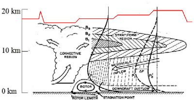 |
| schematic of the M55 flight profile with respect to the MCS structure. The system is propagating toward the left. |
The success of the flight will rely on availability at the Ouagadougou AOC of the radar images in real time from Niamey and Djogou, of the MCS satellite trakings and of good communications between the AOCs and the pilots, this also for safety concerns.
Due to the development and tracking of the system, this flights are more likely to occur in the afternoon. top
top- M55-AMMA-SCOUT-O3 Campaign Team 2006 contact: Sylwester Arabas <slayoo@igf.fuw.edu.pl>, Martin Streibel <Martin.Streibel@ozone-sec.ch.cam.ac.uk>